Range
The new Garmin collars (sold separately) use a high-tech receiver that has the ability to communicate with more satellites than previous Garmin collars. And it uses a combined GPS and GLONASS system, making it able to locate your dog more quickly and maintain its position, even in heavy tree cover or deep canyons. Depending on the terrain, the range of reception can even exceed 14.5 kilometers.
What is GLONASS?
The Global Navigation Satellite System (GLONASS) is based on a formation of active satellites that continuously transmit encoded signals in two frequency bands, which can be received by users anywhere on the Earth's surface to determine their position and speed in real time based on fluctuating measurements. The system is similar to the well-known GPS (Global Positioning System), and both systems share the same principles in both data transmission and positioning methods. GLONASS is managed for the Russian Federal Government by the Russian Space Agency and the system is operated by the Scientific Information Coordination Center (KNITs) of the Ministry of National Defence of the Russian Government.
Attach the collar and get started!
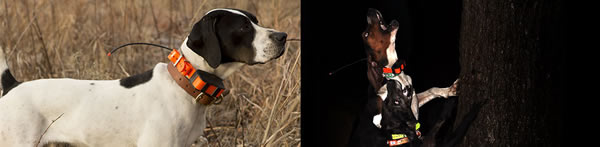
To get started, simply turn on the T5 transmitter (sold separately) and Alpha 50 GPS handheld receiver once you're at the outdoor hunting launch site to get a GPS satellite signal. Then place the T5 collar on your dog and you're ready to go. No other setup is required.
Route through dense vegetation
From the moment you activate the Alpha 50 GPS system, every 2.5 seconds the T5 collar (sold separately) transmits its geographical position to the handheld receiver via VHF signal, so you can see your dog's current position on the screen of your handheld, as well as on the map page the track of its route from the starting point to its current position. If you now go to the dog tracker page a compass will appear on the screen showing his position in relation to you and magnetic north, as well as his status, i.e. whether he is running or stopped. The Alpha 50 GPS system can also generate an audible alarm to immediately notify you when your dog is in danger of going out of the system's control zone (14.5 km) or if it is approaching a point of interest that you have pre-selected (waypoint).
GARMIN, a pioneer in the manufacture of GPS (Global Position System) systems, is proud to build the highly sensitive Alpha 50 GPS system that is able to track your dog even in the densest vegetation. You can simultaneously track UP TO 20 DOGS at a distance of up to 14.5 kilometers (in a straight line). The collar transmits the information to your portable receiver via VHF terrestrial signal having the ability to cover the distance of 14.5 kilometers in a straight line without obstacles.
Memorizing game positions and points of special interest
The Alpha 50 GPS system is able to record - store in the memory of the Counter special way-point the time, the exact position, the time of day and the altitude where you found your prey, as well as the number of game you hit at that position.
You can even save points for tabs that you have marked with special icons.
The Alpha 50 GPS even provides you with the ability to memorize various waypoints of special interest such as my car, my house, gas stations etc etc in an easy and quick way so that you can reuse them in future hunts in those areas you have saved.
Complete GPS experience
The Alpha 50 GPS is - now - an essential tool when you are on the hunt but at the same time it excels as a simple GPS showing you the way at the end of the day to your car or even on your way back home. In fact the Alpha 50 GPS besides the build quality guaranteed by the world renowned for reliability GARMIN has all the features of portable outdoor GPS devices including altimeter (barometric altimeter) electronic compass, micro SD memory card slot, celestial sun and moon information, as well as high waterproofing class IPX7.
TOPO Drive Hellas pre-loaded map:
the TOPO Drive Hellas meets all the latest Garmin quality standards and has unprecedented features such as 3D imaging, 10m levels, navigable paths etc.
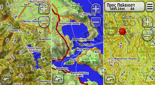
Coverage:
-7,700 fully navigable cities / towns with roads and numbering (or only roads) throughout Greece
-412,000 km of paved and dirt roads (99.99% coverage)
-12,500 settlements, villages with road connections
-41,000 place names (e.g. mountain tops, harbours, bays, bays etc. ) and the entire water network (rivers, lakes, springs)
-195,000 Points of interest (airports, banks, bars, bus stops, churches, cinemas, hospitals, restaurants, petrol stations, hotels, museums, ports, parking, pharmacies, schools, post offices, etc.)
-5,000 fully navigable paths throughout Greece
General features
-Extremely easy to use and friendly Greek menu with Greek characters
-Unique design, colour LCD screen 2,6'', 65. 000 colors
-Capability of notifications either via vibration or audio
-Capability of locking the keyboard
-Capability of wireless data transfer (either stored data or the collar) between compatible devices
-Has a pre-loaded road and topographical map of Greece TopoDrive Hellas, RecMap Europe 100k map and one year free subscription to BirdsEye Satellite Imagery satellite coverage -Pro-loaded profiles & ability to create dog profiles
-Up to 20 hours of autonomy (AA batteries)
-Electronic 3-axis compass for accurate dog positioning
-Barometric altimeter for true altitude indication
-Receiver high-sensitivity receiver with amazing reception performance even in dense vegetation
- Supports Garmin Custom Maps and BirdsEye™ Satellite Imagery
- Ability to add a larger antenna to increase range up to 30%
- Maximum range 14, 5 km. , Multiple collars tracked from one device
-Adding new features to the menu for even greater convenience (e.g. indication of dogs out of map zoom, management of dog data logging)
Two-year Greek warranty
Package contents
-Alpha 50 with pre-loaded Topo Drive Hellas map & BirdsEye satellite map
-12 cm antenna for Alpha 50
-33 cm large antenna for Alpha 50 for increased range
-Belt clip
- USB cable available within the package.